Park at Portola Parkway east of Lutheran HS

dealcatcher

New member
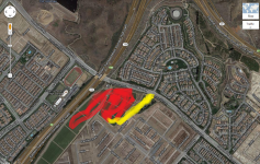
I remember seeing the original drawings for the park that was planned to go east of the Lutheran HS, south of Portola Parkway. I recently drove by the site and noticed that they appear to have made the park a lot smaller than planned. It's just the sliver of the land, whereas in the drawings it looked like the whole section was going to be a park. Instead, it looks like they started building houses there. Does anyone have any information on this?
 
Where in that thread does it say that low income housing is going in the lot that I speak of. The model homes that are going up there right now don't look like low income. They're SFRs and look fairly large.
 
The land east of the 133 will include Sage II (far corner away from freeway), Willow (northern part of area close to freeway), and Cariz (southern part of area close to freeway). Sage II is bounded by Native Springs and Arrowhead, with Bright Poppy leading into the neighborhood. Next to Sage II is Valley Vista Park. This area, in my opinion, will be O.K. (further away from dump, but also not too close to the freeway). Origin leads into Willow and Capricorn connects all of these condos close to the freeway. Cariz is bounded by Renewal and Plateau. The area in between Willow and Cariz will be Center Terrace Park. It looks like the only way into this area will be via Portola Parkway.  :( Poor Whistler, Hawthorn, and Sagewood Phases Past 5.

Valley Vista Park (between Springhouse and Sage II):

Lap Pool
Children?s Wading Pool
Spa
Tot Lot
Half Basketball Court
Barbecue and Picnic Areas
Shade Structures

Center Terrace Park

Lap Pool
Spa
Tot Lot
Shade Structures
Barbecue and Picnic Areas
 
I'm talking about that triangular section in the map where Sage is. That was originally slated to be one giant park and now seems to have been reduced to that long sliver to the right of it called Valley Vista Park.
 
Ok, see attached pic. Section in red was originally slated to be all park w/community pool and clubhouse. Now it appears it has been reduced to the yellow section.
 

Attachments

  • map.png
    map.png
    1.3 MB · Views: 133
Right.. so og supposed to be a park.  Then PP probably went up and TIC changed their minds.. built some condo/apartments.. the south building will be low income. 
 
Trav25 said:
What south building will be low income?

it's on another thread.. but there are 5 or 6 buildings all together.. so the most southern one.. close to Irvine Blvd is low income. 
 
dealcatcher said:
Ok, see attached pic. Section in red was originally slated to be all park w/community pool and clubhouse. Now it appears it has been reduced to the yellow section.

So....  high density housing in lieu of a park.  What's not to like?
 
Back
Top