You are using an out of date browser. It may not display this or other websites correctly.
You should upgrade or use an alternative browser.
You should upgrade or use an alternative browser.
Another Wildfire
- Thread starter iacrenter
- Start date
NEW -> Contingent Buyer Assistance Program

Wow, evacuation zone is right across the street from me. Amazing that it's all the way down to Irvine Blvd.

I hope you are as prepared as Paris. Keep your Porsche gas tank full and have your bags ready to go. I hope the fire doesn't head East when the winds pickup again this morning.

Keeping my eye on it.
Saw around 100 fire trucks leaving the Great Park this morning. They are split up into groups containing the fire, east, west, south and north
Yup, I was ready to leave if the fire jumped Tustin Ranch Road. Thankfully looks like the worst is behind us.

I agree, people won't be deterred from buying. You'll just pay more for homeowner's insurance. I remember the 1993 Laguna Beach fire and hundreds of homes were destroyed. That didn't stop folks from buying.
Yeah, it could have been real bad if the winds were stronger and kept going for 2-3 days.
Nothing will happen.
14 houses but look at where they were............. all over the map except for that one street in Anaheim Hills. I saw an interview with one of the homeowners whose home was destroyed on that street. He spoke of the "last" fire 10 years ago which he thought would hit his house but the wind changed. Didn't stop home sales there at all.
http://www.ocregister.com/2017/10/09/this-map-shows-where-the-anaheim-hills-brush-fire-is-burning/
The fire icon shows the homes that were burned along with their addresses.
If I lived in OH I would definitely make sure I had documentation of everything in my house on video and scan receipts. That place is "due" for another fire. It was threatened in 1997 but the wind changed, parts burned in 2007 and here it is 2017.

This says 3,500 structures are under threat as of this morning. Unfortunately, it doesn't say which city. The fire was moving east.
http://www.fire.ca.gov/current_incidents/incidentdetails/Index/1881
usctrojancpa
Well-known member
aquabliss said:Evacuation Map being updated at this location:https://t.co/ezuWhaLpWL?amp=1
Wow, evacuation zone is right across the street from me. Amazing that it's all the way down to Irvine Blvd.
iacrenter
Well-known member
USCTrojanCPA said:aquabliss said:Evacuation Map being updated at this location:https://t.co/ezuWhaLpWL?amp=1
Wow, evacuation zone is right across the street from me. Amazing that it's all the way down to Irvine Blvd.
I hope you are as prepared as Paris. Keep your Porsche gas tank full and have your bags ready to go. I hope the fire doesn't head East when the winds pickup again this morning.
irvinehomeowner
Well-known member
So how is everyone? I had a few friends who had to evacuate yesterday.
paperboyNC
New member
irvinehomeowner said:So how is everyone? I had a few friends who had to evacuate yesterday.
Keeping my eye on it.
paperboyNC
New member
iacrenter said:Conditions seem better today. Less smoke is visible from our area. We were lucky and had no mandatory evacuations. I hope the OCFA can keep the fire contained on the Eastern side of the 241.
Saw around 100 fire trucks leaving the Great Park this morning. They are split up into groups containing the fire, east, west, south and north
RangeRover
New member
It's nice that the Irvine Police Department has been constantly informing updates on Nextdoor and now they've announced another emergency alert app that the community can be informed.
http://www.cityofirvine.org/office-emergency-management/stay-informed-ialert
http://www.cityofirvine.org/office-emergency-management/stay-informed-ialert
usctrojancpa
Well-known member
iacrenter said:USCTrojanCPA said:aquabliss said:Evacuation Map being updated at this location:https://t.co/ezuWhaLpWL?amp=1
Wow, evacuation zone is right across the street from me. Amazing that it's all the way down to Irvine Blvd.
I hope you are as prepared as Paris. Keep your Porsche gas tank full and have your bags ready to go. I hope the fire doesn't head East when the winds pickup again this morning.
Yup, I was ready to leave if the fire jumped Tustin Ranch Road. Thankfully looks like the worst is behind us.
Hugo Township
Active member
In something like this, what happens to the listings in Anaheim Hills, Orange Park Acres, etc? I wonder if sales fall through in an environment like this.
Only 14 houses burned. While that may be a lot, it's not close enough to change the market IMO.HMart said:In something like this, what happens to the listings in Anaheim Hills, Orange Park Acres, etc? I wonder if sales fall through in an environment like this.
Dresden215
Active member
spootieho said:Only 14 houses burned. While that may be a lot, it's not close enough to change the market IMO.HMart said:In something like this, what happens to the listings in Anaheim Hills, Orange Park Acres, etc? I wonder if sales fall through in an environment like this.
I agree, people won't be deterred from buying. You'll just pay more for homeowner's insurance. I remember the 1993 Laguna Beach fire and hundreds of homes were destroyed. That didn't stop folks from buying.
nosuchreality
Well-known member
Yesterday, the Santa Ana's weren't blowing like they normally do. Normally, the Santa Ana's come over the hill and out of the canyon blow like a wind tunnel through Cowan Heights, Tustin Ranch, OPA, Villa Park.
The fire burned Peters Canyon. JIMHO, Peters Canyon was burning and if the wind did a typical Santa Ana wind, Tustin Ranch and Cowan Heights would be looking like the neighborhood in Santa Rosa and OCFA might to have had the discussion if the fire line to try and hold was the 5 & 55 FWYs.
That area is hilly and full of fuel..
#feelingblessedandthankful
usctrojancpa
Well-known member
nosuchreality said:Yesterday, the Santa Ana's weren't blowing like they normally do. Normally, the Santa Ana's come over the hill and out of the canyon blow like a wind tunnel through Cowan Heights, Tustin Ranch, OPA, Villa Park.
The fire burned Peters Canyon. JIMHO, Peters Canyon was burning and if the wind did a typical Santa Ana wind, Tustin Ranch and Cowan Heights would be looking like the neighborhood in Santa Rosa and OCFA might to have had the discussion if the fire line to try and hold was the 5 & 55 FWYs.
That area is hilly and full of fuel..
#feelingblessedandthankful
Yeah, it could have been real bad if the winds were stronger and kept going for 2-3 days.
Ready2Downsize
Well-known member
HMart said:In something like this, what happens to the listings in Anaheim Hills, Orange Park Acres, etc? I wonder if sales fall through in an environment like this.
Nothing will happen.
14 houses but look at where they were............. all over the map except for that one street in Anaheim Hills. I saw an interview with one of the homeowners whose home was destroyed on that street. He spoke of the "last" fire 10 years ago which he thought would hit his house but the wind changed. Didn't stop home sales there at all.
http://www.ocregister.com/2017/10/09/this-map-shows-where-the-anaheim-hills-brush-fire-is-burning/
The fire icon shows the homes that were burned along with their addresses.
If I lived in OH I would definitely make sure I had documentation of everything in my house on video and scan receipts. That place is "due" for another fire. It was threatened in 1997 but the wind changed, parts burned in 2007 and here it is 2017.
nosuchreality
Well-known member
Not to mention neither this fire nor the prior have the cause identified. So IMHO, a fire bug or maybe a careless smoker, I know I've seen plenty flicking their cigarette out the window on the 241 and 91, or some other cause. I'd put my money on fire bug though.
socal78
Well-known member
Can't seem to find many updates for east of the toll road, where I am (I'm in Foothill Ranch). Frustrating. Last I heard, the fire was 40% contained, the west side was halted, but the fire was still moving east as of last night. The last fire map I saw had the fire not far from F.R. if the wind starts again. Winds are expected to kick up tomorrow so we may not be out of the woods yet.
I loved this news clip. I feel the exact same as this lady. Living up in the foothills, surrounded by dry brush, and having been confronted with fire a few times, I have the attitude that if anything should happen, the house is just an accumulation of stuff. It's all replaceable. The people in it are what's important.
https://www.facebook.com/ocregister...va4gODn8K1aAWrSfY3zkxqR61BTlowOB90VSuEZuSaph4
socal78
Well-known member
USCTrojanCPA said:Thankfully looks like the worst is behind us.
This says 3,500 structures are under threat as of this morning. Unfortunately, it doesn't say which city. The fire was moving east.
http://www.fire.ca.gov/current_incidents/incidentdetails/Index/1881
socal78
Well-known member
60% containment as of this morning. Full containment expected by Saturday. I guess I can stop playing my daily dose of John Mayer on repeat. Or not. Pretty sure he makes that guitar cry harder than Trojan would have if his fleet of cars had burst into flames.
https://www.youtube.com/watch?v=32GZ3suxRn4
https://www.youtube.com/watch?v=32GZ3suxRn4
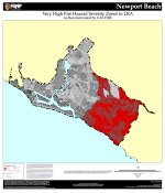
It's important to note that this a fire like this can happen ANYWHERE, regardless of where you live relative to the coast. Fire hazard zone maps (FHZMs) show that the entirety of Newport Coast is considered to be located in a high-risk fire area, according to Cal Fire. Huge swaths of Shady Canyon and Turtle Rock are also considered to be located in a high-risk area, more than the residential areas of Orchard Hills! Santa Ana winds pose a risk anywhere in Southern California that lies adjacent to nature preserves, considering the dry native grasses that grow here. So if you live in a hillside community anywhere in Central Orange County, whether it's in Pelican Hill or Portola Springs, remain vigilant! Exercise fire safety with your families, and discuss what you would need to pack in the possible event of evacuation.
Here are the original, more clear maps. Though, the files are huge, and may crash your computer.
Newport Beach:http://www.fire.ca.gov/fire_prevention/fhsz_maps/FHSZ/orange/c30_NewportBeach_vhfhsz.pdf
Irvine:http://www.fire.ca.gov/fire_prevention/fhsz_maps/FHSZ/orange/c30_Irvine_vhfhsz.pdf
Tustin:http://www.fire.ca.gov/fire_prevention/fhsz_maps/FHSZ/orange/c30_Tustin_vhfhsz.pdf