Another Wildfire

I don't see how Cameo Shores, Pelican Point, and southern CdM can be a high fire risk zone. It's right next to the ocean! Thanks for sharing anyways.
 
HMart said:
I don't see how Cameo Shores, Pelican Point, and southern CdM can be a high fire risk zone. It's right next to the ocean! Thanks for sharing anyways.
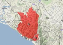
Shocking, but important to know! Being coastal does not make you immune to an uncontrollable fire. We shouldn't forget that the Laguna Beach Fire in 1993 was one of the most destructive fires in the state of California, and the most destructive in Orange County--ever. 441 homes were severely damaged, and over 60 homes were completely destroyed, most of them in Emerald Bay!! The fire burned through Laguna Beach (of course) and through where Newport Coast, Turtle Ridge, Shady Canyon, and parts of Quail Hill sit today.
http://www.latimes.com/tn-cpt-me-1023-1993-fire-gallery-20131023-photogallery.html
 

Attachments

  • Laguna Beach Fire.jpg
    Laguna Beach Fire.jpg
    52.3 KB · Views: 228
HMart said:
I don't see how Cameo Shores, Pelican Point, and southern CdM can be a high fire risk zone. It's right next to the ocean! Thanks for sharing anyways.

Villager already mentioned it but there was a huge fire in Laguna Beach. I remember you can see from Turtle Rock and they were evacuating certain neighborhoods up there.

The chances are higher inland (as we've seen more of those fires since 1993) but in dry weather like we've been having, it can happen anywhere.
 
Here's drone video and  image of Santa Rosa fire devastation.  Unbelievable

http://www.pressdemocrat.com/news/7522487-181/drone-video-shows-postal-worker?gallery=7515439&artslide=10
https://youtu.be/3wsegE01zUE
dt.common.streams.StreamServer.cls
 
https://www.ocregister.com/2018/06/11/brush-fire-breaks-out-along-241-toll-road-in-orange-county/

100-acre brush fire breaks out along 241 Toll Road in Orange County

By KELLY PUENTE | kpuente@scng.com | Orange County Register
PUBLISHED: June 11, 2018 at 5:34 pm | UPDATED: June 11, 2018 at 7:16 pm

Firefighters Monday afternoon were battling a fast-moving brush fire that had so far scorched about 100 acres near the 241 Toll Road just west of Santiago Canyon Road.

Orange County Fire Authority Capt. Tony Bommarito said the blaze started just before 5 p.m. More than 300 firefighters were on scene along with six helicopters and six fixed-wing aircraft.

He said firefighters planned to hold the fire west of Santiago Canyon Road. No structures were immediately threatened, but that could change if the blaze jumps Santiago Canyon Road.

The fire, fueled by six- to eight-mile-per-hour winds, was moving quickly and has potential to grow to 500 hundred acres, he said.

The blaze is moving over an area that burned a few years ago, which means it?s faster than last week?s Aliso Fire, which burned a thick brush area that hadn?t seen fire in more than 100 years, he added.

?With the wind behind it, it moves very quickly,? he said.

The northbound 241 Toll Road was closed, he said, adding that multiple agencies were responding to help.
 
The entire Irvine sky is pretty much covered with the smoke of this Holy Fire from Lake Elsinore. Everything is red orange-ish outside.  :(
 
Mety said:
Dresden215 said:
Saw a big plume of smoke from the Holy fire while exiting OH. Hopefully it doesn?t head towards Santiago Peak.

https://hpwren.ucsd.edu/cameras/I/sp-e-mobo-c.html

Holy Smokes! Is that visible from OH?

I was driving on the 5 freeway southbound towards sand canyon tonight and could clearly see the fire ridge line at the peak of the mountain. It looked really close to Irvine! I wonder if it's at the top of Santiago Peak, anyone know?
 
Go to Twitter
#holyfire

Some crazy pics there
Mention one structure down
Hats off to fire fighters...
 
Check the OCFA_PIO page on twitter
People seem to be saying that the fire may be on Modjeska peak, east of Santiago
Stay Safe, everyone
 

Attachments

  • DkOArpzUcAAe-tI.jpg
    DkOArpzUcAAe-tI.jpg
    107.3 KB · Views: 173
Back
Top